Analyse complète du fleuve Tano (Tanoé) et de son bassin
Cet article n’est pas encore disponible en français : vous lisez la version originale en anglais. Voir la page anglaise
Introduction
The Tano River, also identified as Tanoé, represents a critical transboundary hydrological system in West Africa, traversing both Ghana and Côte d'Ivoire before its eventual discharge into the Atlantic Ocean. This report offers an exhaustive examination of the Tano River and its extensive basin, covering its geographical characteristics, hydrological dynamics, ecological importance, socio-economic contributions, prevalent environmental challenges, and ongoing conservation initiatives. The objective is to establish a foundational resource for understanding this vital waterway and its intricate connections with the surrounding environment and the communities it sustains.
The Tano River is a shared natural asset of considerable ecological and socio-economic value, necessitating a comprehensive understanding of its attributes and the pressures it faces.
1. Geographical Profile
This section delineates the physical attributes of the Tano River and its expansive basin, detailing its location, dimensions, and geological foundations.
1.1. Location, Extent, and Administrative Divisions
The Tano Basin functions as a transboundary river system, predominantly situated within Ghana but extending into Côte d'Ivoire. It is recognized as one of Ghana's four primary southwestern river systems, alongside the Ankobra, Bia, and Pra rivers. Geographically, the basin is positioned between latitudes 5°00' N and 7°40' N and longitudes 1°48' W and 3°05' W, encompassing the western-northern part of Ghana. Minor variations in reported coordinates exist, with another source indicating its location between Latitudes 5° N and 7° 40' N and Longitudes 2° 00' W and 3° 15' W. Such slight differences are common in geographical mapping, often reflecting the specific methodologies or focus areas of different studies.
The total hydrological area of the basin is approximately 16,060 square kilometers (km²), with a significant portion, about 92.6% (14,875 km²), located within Ghana, and the remaining 7.4% (1,185 km²) extending into Côte d'Ivoire. A consistent estimate from another source places the total catchment area at around 15,000 km², with 93% in Ghana and 7% in Côte d'Ivoire. These figures generally align, providing a clear definition of the hydrological basin's extent.
The basin spans several administrative regions within Ghana, with approximately 40% of its area in the Western North Region, 25% in the Ahafo Region, 15% in the Ashanti Region, 10% in the Western Region, 8% in the Bono Region, and 2% in the Bono East Region. Broader classifications also indicate its presence across the Brong Ahafo, Ashanti, and Western Regions, encompassing 21 administrative districts. This detailed administrative breakdown underscores the multi-jurisdictional nature of the basin within Ghana, influencing regional planning and resource management.
A crucial distinction arises when considering the term "Tano Basin." While the hydrological basin, as described above, covers approximately 15,000-16,060 km² and pertains to the river's catchment, other references to a "Tano basin" refer to a much larger area of 104,000 km². This larger "Tano basin" is specifically noted for its endowment with minerals, oil, and gas resources. This difference highlights that the term "basin" can refer to distinct geological sedimentary basins—large depressions in the Earth's crust where sediments accumulate, often associated with hydrocarbon deposits—as opposed to the hydrological basin that defines a river's drainage area. The presence of significant oil and gas fields, such as Jubilee, Sankofa & Gye Nyame, and Tweneboa, Enyenra & Ntomme (TEN) fields, within this broader geological basin indicates substantial economic activity and infrastructure development. These activities, while not directly within the river's immediate catchment, can exert considerable indirect pressures on the river system through population influx, industrial effluents, and land-use changes, thereby influencing the ecology and water quality of the hydrological basin. Understanding this dual interpretation of "Tano Basin" is essential for a comprehensive view of the region's resource landscape and associated environmental considerations.
1.2. River Course: Source, Length, Mouth, and International Boundary
The Tano River originates from the Boyem Mountain Ranges near Techiman , specifically within the forest at Pooyem, approximately 4 km from Techiman. Another account identifies the source town as Traa, a suburb of Techiman. These sources consistently locate the river's genesis in the Techiman area. The river flows generally southwestward or roughly north-south for an approximate length of 400 kilometers.
The Tano River ultimately discharges into the Gulf of Guinea, part of the Atlantic Ocean. More precisely, it flows into a complex lagoon system comprising Ehy Lagoon, Tendo Lagoon, and finally Aby Lagoon in Côte d'Ivoire before entering the Atlantic. A notable characteristic is that the majority of this terminal lagoon system lies within Côte d'Ivoire. The river's lower course also serves as the final few kilometers of the international land boundary between Ghana and Côte d'Ivoire.
The river is navigable from its mouth for approximately 60 miles (95 km) inland to Tanoso, where further upstream travel is impeded by the Sutre Falls. This navigability constraint limits the potential for extensive inland water transport, concentrating water-dependent economic activities closer to the river's mouth or necessitating alternative land-based infrastructure for areas further upstream. This geographical feature thus plays a role in shaping the distribution and types of economic activities along the river's course.
1.3. Major Tributaries and Drainage Network
The Tano River system is characterized by a well-developed drainage network, encompassing the main river and numerous tributaries that contribute to its overall flow and drainage density. Key tributaries identified include the Boin (with a sub-basin area of 821 km², of which 655 km² is in Ghana), Disue (1,715 km², with 1,709 km² in Ghana), Amama (958 km²), Abu (1,650 km²), Gaw (984 km²), Suraw (640 km²), Samre (487 km²), Totua (440 km²), and Disri (370 km²). Another comprehensive list of tributaries includes Abu, Amama, Bo, Disue, Soro, Atronie, Sabom, Gaw, Kwasa, Sumre, and Totua. The confluence of these various waterways forms an interconnected system vital for supporting local ecosystems, agricultural practices, and livelihoods throughout the basin area.
1.4. Topography and Geological Formations
The topography of the Tano Basin varies significantly across its expanse. The overall elevation ranges from 0 to 700 meters above mean sea level. Upstream regions are characterized by highlands, with average elevations around 540 meters above sea level, particularly near the Boyem Mountain Ranges, where the river originates. As the river flows downstream, the middle sections of the basin exhibit a drop in elevation, typically ranging from 200 to 300 meters. The southern areas, closer to the coast, are considerably flatter, with elevations between 0 and 15 meters, and an average elevation of 50 meters above sea level.
The geological foundation of the Tano Basin is primarily defined by Ghana's extensive Birimian complex, which is largely composed of crystalline igneous and metamorphic rocks. The landscape is predominantly underlain by metamorphosed and folded rocks belonging to the Birimian system, a key element in the region's geological structure.
The main geological formations within the basin and their approximate areal distribution are:
- Granite (Granitoids): 38.1% (dominant)
- Birimian Sediments: 31.9%
- Birimian Volcanics: 25.5%
- Eocene & Cretaceous Sedimentary Rocks
- Upper Voltaian (Kwahu Group): 1.8%
- Tarkwaian Rocks: 0.6% (least dominant)
The Birimian series, comprising slates, phyllites, greywackes, tuffs, and minor lava flows, are highly folded, foliated, and jointed. This geological characteristic facilitates water infiltration and groundwater movement through fractures and weak zones. Although less extensive, the Tarkwaian rocks are slightly metamorphosed and folded, featuring open joint systems that can support limited groundwater storage and movement. The Upper Voltaian (Kwahu Group), located in the northern part of the basin, is recognized as the thickest and coarsest formation in that area, and its structure and composition directly influence groundwater occurrence in that section.
Table 1: Key Geographical Statistics of the Tano River Basin
| Characteristic | Data | Source |
|---|---|---|
| Hydrological Basin Area (Total) | ~15,000 - 16,060 km² | |
| Hydrological Basin Area (Ghana) | ~13,700 - 14,875 km² (92.6-93%) | |
| Hydrological Basin Area (Côte d'Ivoire) | ~1,185 - 1,683 km² (7-7.4%) | |
| River Length | 400 km | |
| Source Location | Boyem Mountain Ranges / Pooyem, near Techiman, Ghana | |
| Mouth Location | Aby Lagoon (via Ehy & Tendo Lagoons), Gulf of Guinea, Côte d'Ivoire | |
| Navigable Length | ~95 km (to Sutre Falls) | |
| Major Tributaries | Boin, Disue, Amama, Abu, Gaw, Suraw, Samre, Totua, Disri, Bo, Soro, Atronie, Sabom, Kwasa, Sumre | |
| Dominant Geological Formations | Granite (38.1%), Birimian Sediments (31.9%), Birimian Volcanics (25.5%) | |
| Geological Basin Area (Hydrocarbon) | 104,000 km² |
The transboundary nature of the Tano River and its basin, shared between Ghana and Côte d'Ivoire, presents inherent complexities for resource management. Any effective strategy for the Tano River must account for this shared jurisdiction. This necessitates bilateral agreements, joint monitoring programs, and collaborative governance structures between the two nations. Unilateral actions by either country, particularly concerning water abstraction, pollution discharge, or resource exploitation, could have significant upstream or downstream repercussions, potentially leading to disputes over water use or environmental degradation. The establishment of the Tano Basin Board, mentioned in available documentation , indicates an understanding of the necessity for integrated management. However, the challenges associated with managing a shared resource across international borders, especially given potentially divergent national priorities (e.g., Ghana's focus on riverine resources versus Côte d'Ivoire's interests in the lagoon system at the river's mouth or the broader geological basin's hydrocarbon potential), remain substantial.
2. Hydrology and Water Resources
This section examines the climatic conditions, water flow dynamics, groundwater characteristics, and the critical aspects of water quality within the Tano River Basin.
2.1. Climate and Rainfall Patterns
The Tano Basin experiences a climate that transitions between the wet semi-equatorial and south-western equatorial climatic zones of Ghana. This results in a distinctive pattern of double rainfall maxima annually. Rainfall is typically bi-modal, with a significant rainy season occurring from March to July, followed by a minor season from September to November. August generally marks a brief dry spell.
The mean annual rainfall across the basin is approximately 1390 mm. However, there is a spatial variation in rainfall accumulation, ranging from 1100 mm in the northern parts to 1800 mm in the southern regions, with rainfall intensity generally increasing towards the south. The average annual temperature in the basin is recorded at approximately 25.8°C or 25.9°C. Relative humidity remains consistently high throughout the year, ranging between 75% and 85%.
2.2. River Flow, Discharge Characteristics, and Runoff
The Tano River system serves as a crucial source for domestic water supply, both from surface water and groundwater. Its waters are also extensively utilized for industrial purposes, mining operations, and irrigation within the basin. While the Tano River is not listed among the world's largest rivers by average discharge , quantitative discharge data for the basin is available by country. Ghana contributes an annual discharge of 20 cubic kilometers (km³) of water, while Côte d'Ivoire contributes 1 cubic km³, resulting in a total basin-wide discharge of 21 cubic km³ per year.
Annual runoff figures further detail the water balance: the Ghanaian portion of the basin experiences an annual runoff of 1,093 mm/yr, whereas the Ivorian portion has a lower runoff of 365 mm/yr. It is important to note an apparent discrepancy in one document which mentions an "average runoff of 2774 mm3" ; this figure is likely a typographical error, as runoff is typically expressed in mm/year or as a total volume in cubic meters. The segmented runoff data from provides a more coherent and credible representation of the basin's hydrological output.
Seasonal variations significantly influence the river's characteristics. Studies indicate that concentrations of heavy metals in both water and sediment samples are notably higher during the rainy season compared to the dry season, with the exception of lead (Pb) and cadmium (Cd) in sediment, which show higher concentrations in the dry season. This pattern suggests a flush of accumulated pollutants from the land into the river system during periods of high flow, highlighting the impact of seasonal hydrological cycles on water quality.
2.3. Groundwater Resources and Hydrochemical Properties
The Tano Basin possesses substantial groundwater resources, which are a vital component of its overall water supply. Investigations into the aquifer hydraulic parameters within the Lower Tano River basin have revealed a mean transmissivity of 5.96 m²/day, a hydraulic conductivity of 5.70 m/day, and a specific capacity of 18.80 L/min/m.
Groundwater extracted from the Apollonian formation and Birimian supergroup aquifers is generally characterized as fresh. Most samples exhibit soft water properties, with a smaller proportion being moderately hard or hard. Evaluations based on residual sodium carbonate and permeability index classifications indicate that this groundwater is suitable for irrigation purposes.
The hydrochemical characteristics of the groundwater are primarily influenced by natural processes such as ion exchange, rock-water interaction, and incongruent dissolution. However, the presence of sulphate in groundwater suggests potential impacts from the oxidation or mobilization of sulphide minerals (e.g., pyrites, arsenopyrites, chalcopyrite) and from mining activities, including both legal and illegal small-scale operations. An analysis of groundwater samples collected in 2016 demonstrated an evolution in hydrochemistry along the flow direction, transitioning from a Ca-HCO₃⁻ water type to Ca-SO₄²⁻, and subsequently to an NaCl water type. This evolution was attributed to ongoing ion exchange processes and interactions between the water and surrounding rock formations.
Stable isotope compositions (δ¹⁸O and δ²H) of rainwater indicate minimal evaporation, and the regression lines for rainfall are similar to the local meteoric water line for Ghana and the global meteoric water line. Isotopic analysis of surface water (rivers, streams, lagoons, and seawater) and groundwater (hand-dug wells and boreholes) further reveals that aquifer recharge is rapid and primarily sourced from meteoric water, with surface water bodies contributing to groundwater replenishment in the Lower Tano River Basin. Tritium concentrations in rainfall range from 1.27 to 10.11 Tritium Units (TU), in rivers from 2.04 to 3.08 TU, and in groundwater from 0.99 to 6.78 TU. These tritium results indicate that the groundwater from the Apollonian formation and Birimian supergroup aquifers is relatively young, indicative of modern recharge with short residence times, having been recharged between the periods of 1960-1965 and 1965-1970.
2.4. Water Quality: Physicochemical Parameters, Heavy Metals, and Microbial Contamination
Water quality in the Tano Basin is a complex issue, with varying assessments depending on the specific parameters analyzed, sampling locations, and timeframes of study.
Physicochemical Parameters: A study conducted from January to October 2016 found that seasonal averages for several key physicochemical parameters, including Chemical Oxygen Demand (COD), Biochemical Oxygen Demand (BOD), chloride (Cl⁻), sodium (Na⁺), magnesium (Mg²⁺), calcium (Ca²⁺), total hardness (TH), sulphate (SO₄²⁻), nitrate (NO₃⁻), and phosphate (PO₄³⁻), did not exceed the World Health Organization (WHO) standards for drinking water. Potassium (K⁺) concentrations also remained below the European Union (EU) threshold. This suggests that, for these specific parameters and during the study period, the water quality was generally acceptable for drinking purposes according to WHO (2011) guidelines.
Heavy Metals: The assessment of heavy metal contamination presents a more nuanced picture, with some apparent inconsistencies in the available data, likely attributable to differences in sampling protocols, spatial coverage, and analytical methods.
- A study conducted from November 2016 to October 2017 analyzed concentrations of mercury (Hg), cadmium (Cd), zinc (Zn), lead (Pb), arsenic (As), copper (Cu), and chromium (Cr). This research indicated that metal concentrations were generally higher during the rainy season in both water and sediment, except for Pb and Cd in sediment, which were higher in the dry season. Spatially, the river's source was found to be unpolluted for all metals in both seasons. However, the midstream and downstream sections of the river exhibited heavy pollution by Hg, Pb, and Cd. Critically, all heavy metals examined in this study, with the exception of Zn, exceeded the WHO standards for drinking water. In the sediment, concentrations of Cd, Hg, and Cr surpassed the United States Environmental Protection Agency (USEPA) guidelines, with Hg and Cd showing moderate to heavy pollution levels. This suggests localized, severe contamination in certain river stretches.
- Conversely, another study (January-October 2016) reported that Potentially Toxic Elements (PTEs) including iron (Fe), Pb, Cu, Cd, Hg, nickel (Ni), and Zn did not exceed the WHO (2011) limit values.
The divergence in these findings can be attributed to several factors. The study reporting exceedances specifically highlighted pollution in "midstream and downstream ends," implying localized hotspots rather than a basin-wide uniform condition. The other study might have included broader sampling points or different monitoring stations, leading to a more generalized, and seemingly less critical, assessment. The implication is that while some areas of the Tano River may maintain acceptable heavy metal levels, specific segments, particularly those impacted by anthropogenic activities downstream, pose significant health risks if untreated water is used for domestic purposes. This underscores the necessity for targeted interventions and enforcement of environmental regulations in these polluted zones.
Microbial Contamination: The Tano River Basin faces substantial challenges from microbial contamination, primarily from various point and nonpoint pollution sources. Factors such as raw urban and rural effluent discharge, open defecation, and polluted agricultural runoff are identified as major contributors to fecal contamination in the river. The absence of adequate sewage treatment facilities exacerbates this problem. A study from June 2022 to April 2023 found high measured and modeled
Escherichia coli (E. coli) concentrations, with the highest levels recorded during the rainy season. This study attributed 44% of E. coli concentrations to point sources (primarily human feces and livestock manure), 34% to upstream pollution, and 22% to non-point sources. Non-point sources became the predominant contributors during periods of maximum discharge due to runoff from land and the dilution of point sources. This highlights the dual challenge of direct waste discharge and diffuse pollution exacerbated by rainfall events.
The overall water quality indices for the Tano River have been categorized as "unfit for drinking water" during both dry and wet seasons in some assessments. This comprehensive assessment of water quality reveals that while some parameters may meet standards, the presence of heavy metal pollution in critical sections and widespread microbial contamination renders untreated river water risky for domestic use.
3. Ecological Significance and Biodiversity
The Tano Basin is an ecologically and economically vital region, supporting millions of people through various sectors including agriculture, forestry, mining, tourism, and fisheries. Its rich terrestrial and aquatic ecosystems provide essential services such as water supply, biodiversity conservation, and climate regulation.
3.1. Terrestrial Ecosystems and Land Cover
The basin's terrestrial landscape is characterized by a mix of diverse vegetation types:
- Semi-deciduous dense forests
- Dry dense forests and clear forests
- Farmlands and degraded lands
Forest cover represents a significant land use pattern, closely following agricultural lands and occupying approximately 50% of the basin's total landmass, with the remaining 40% being protected forest areas. The evergreen forest of the Tano River Basin (TRB) plays a crucial role in sequestering carbon and offers substantial potential for reducing greenhouse gas emissions. However, over the past few decades, human activities have led to significant and rapid changes in the TRB's primary rainforest and biodiversity. Logging and timber harvesting within the forest belt have severely impacted the natural ecosystem. Furthermore, extensive cocoa farming and gold mining are prevalent even within protected areas, further endangering the basin's vegetation and complicating natural resource management.
3.2. Aquatic Ecosystems and Fauna
The Tano River and its tributaries support diverse aquatic life. Fish species identified in studies include Mormyrus rume, Leptocypris niloticus, Oreochromis niloticus, Chrysichthys johnelsi, Clarias gariepinus, Parachanna obscura, Sarotherodon melanotheron, Sarotherodon galilaeus, and Ctenopoma kingsleyae. These species are susceptible to the impacts of water quality degradation.
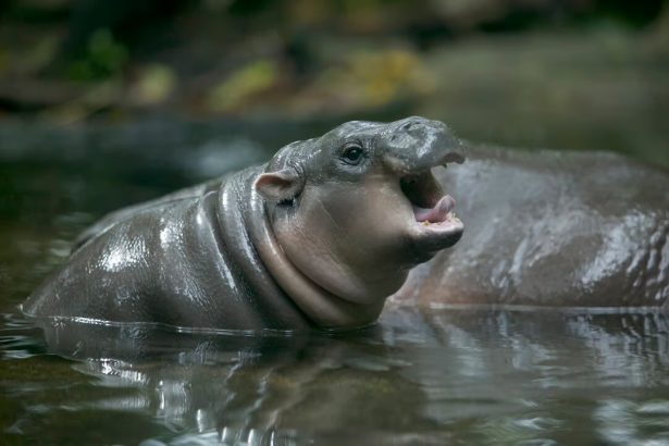
A particular focus of conservation efforts in the basin is the endangered pygmy hippopotamus. Current observations suggest a small herd, including young, resides in an approximately 130 km stretch of the Tano River between Sienkyem (near Goaso in Brong-Ahafo Region) and Tano-Odumase (near Bibiani in Ashanti Region). These hippos face severe threats from over-exploitation due to subsistence and commercial hunting, as well as habitat loss caused by poaching, degradation, fragmentation, and encroachment.
The health of the aquatic ecosystem is directly linked to water quality. The presence of elevated trace metals in fish muscles, such as chromium (Cr), arsenic (As), and mercury (Hg), which exceed acceptable levels for fish consumption , indicates a significant risk to aquatic fauna and, consequently, to human consumers. While some metals like lead (Pb), zinc (Zn), and cadmium (Cd) were found below Food and Agriculture Organization (FAO) limits in fish, the overall picture points to environmental stress. The observation that
Mormyrus rume fish species were under stress in the river, while other species were in good condition , suggests varying sensitivities to pollutants or localized impacts.
4. Socio-Economic Importance
The Tano River Basin is a cornerstone of the regional economy, providing livelihoods and resources for millions of people.
4.1. Agriculture and Land Use
Arable lands constitute the largest percentage of the total landmass within the Tano Basin. Agriculture is the primary economic activity, employing approximately 70% of the labor force. Commercial farming of crops such as cocoa, plantain, cassava, maize, and oil palm is widespread. Extensive cocoa farming, in particular, occurs even within designated protected areas. Coconut plantations are also cultivated along the coastal strip of the basin. The basin's population is estimated at about 2.4 million, with a growth rate of approximately 2.2% per year. Human settlements occupy only about 10% of the landmass.
The reliance on agriculture makes the basin highly vulnerable to environmental changes and degradation. Unsustainable agricultural methods and the expansion of cropland have been shown to contribute to increased CO₂ emissions. This highlights a critical link between agricultural practices, land-use change, and broader climate change impacts.
4.2. Other Industries: Forestry, Mining, Tourism, and Fisheries
Beyond agriculture, the Tano Basin supports several other vital industries:
- Forestry: Logging and timber harvesting are significant activities, often carried out on concessions within the forest belt. This industry, however, contributes to deforestation and habitat destruction within the basin.
- Mining: The basin is important for mining, particularly gold and bauxite. The broader geological Tano Basin is also a significant area for oil and gas production, with major discoveries like the Jubilee Field (2007), Sankofa & Gye Nyame Complex (2008), and Tweneboa, Enyenra & Ntomme (TEN) fields (2009). This extensive hydrocarbon exploration and production activity, while providing national economic benefits, introduces additional environmental pressures and risks to the region.
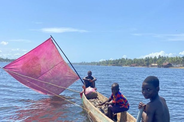
- Fisheries: The Tano River's aquatic ecosystems support local fisheries, contributing to the livelihoods of communities. While specific data for the Tano River basin's contribution to Ghana's overall fishing industry is not detailed, the national fishing sector contributes 3% of the total GDP and 5% of the agricultural GDP, engaging about 10% of the country's population. Inland communities, in particular, can derive a substantial portion (75-85%) of their financial strength from fisheries.
- Tourism: The basin's natural beauty and biodiversity, including species like the pygmy hippopotamus, offer potential for eco-tourism development. Efforts are underway to promote community-managed eco-tourism programs as part of conservation strategies.
The basin's diverse economic activities underscore its importance but also highlight the complex interplay of development and environmental sustainability.
5. Infrastructure and Development
The Tano River Basin's infrastructure primarily supports its agricultural and resource extraction activities, with limited large-scale water infrastructure directly on the main river.
5.1. Dams and Irrigation Projects
Despite the Tano River's significance as a water source, there are no dams specifically identified on the Tano River itself within Ghana or Côte d'Ivoire. This is a notable characteristic, as many major river systems in the region feature extensive dam infrastructure for hydropower or large-scale irrigation. The absence of dams on the main Tano River means its natural flow regime is less directly altered by impoundments, though other factors like climate change and upstream abstractions can still affect its hydrology.
It is important to clarify that the "Tono Dam," frequently mentioned in relation to irrigation schemes, is located in the Upper East Region of Ghana and impounds the Tono River. This is a distinct river system from the Tano River, the subject of this report. The Tono Dam, constructed between 1975 and 1985, is one of West Africa's largest agricultural dams, irrigating approximately 2,490 hectares of land for crops like rice, soybeans, and tomatoes, significantly improving local farmers' livelihoods. Its inclusion in some search results related to the Tano River highlights a potential for confusion due to similar names. The Tano River Basin, however, utilizes its waters for irrigation, industrial, and mining purposes, implying localized water abstraction rather than large-scale dam-fed schemes.
5.2. Navigation Routes
The Tano River offers limited navigability. It can be navigated from its mouth for approximately 60 miles (95 km) upstream to Tanoso. Beyond this point, further travel is obstructed by the Sutre Falls. This geographical constraint means that extensive inland water transport is not feasible along the entire length of the river. Consequently, economic activities that rely on riverine transport are likely concentrated near the mouth or require alternative land-based transportation infrastructure further inland.
5.3. Oil and Gas Infrastructure
The broader geological Tano Basin is a significant hydrocarbon province, with discoveries dating back to 1972. Major oil and gas fields, including Jubilee (discovered 2007), Sankofa & Gye Nyame (2008), and Tweneboa, Enyenra & Ntomme (TEN) (2009), have been identified and developed. These discoveries have transformed hydrocarbon production in West Africa, encouraging further exploration in the Gulf of Guinea. The geological basin's formation, stemming from continental rifting between the African and South American plates during the Jurassic and Cretaceous eras, created an environment conducive to the deposition and preservation of organic matter, leading to the formation of prolific source rocks and hydrocarbon reservoirs. The Turonian play system, in particular, has proven highly productive.
The development of this oil and gas infrastructure implies a substantial industrial presence within the region, encompassing exploration, drilling, production facilities, and associated logistics. While these activities are primarily offshore or within the deeper geological basin, they contribute to population growth, industrialization, and potential environmental risks, such as accidental spills or increased demand for resources, which could indirectly impact the Tano River's hydrological basin and its ecosystems.
6. Environmental Challenges
The Tano River Basin faces a confluence of significant environmental challenges, primarily driven by anthropogenic activities and exacerbated by climate change.
6.1. Pollution from Mining Activities ("Galamsey")
Small-scale gold mining (ASGM), locally known as "galamsey," is a pervasive issue in Ghana and a major source of environmental degradation in the Tano Basin. These activities involve rudimentary extraction methods that lead to severe ecological consequences, including:
- Deforestation and Habitat Destruction: Galamsey causes widespread deforestation and destruction of natural habitats, impacting Ghana's natural beauty and biodiversity.
- Water Pollution: The most direct and severe impact is water pollution. Mining operations release toxic substances such as mercury, cyanide, arsenic, and cadmium into the environment. Elevated levels of these heavy metals have been detected in the Tano River's water and sediment, particularly in the midstream and downstream sections, exceeding WHO standards for drinking water and USEPA guidelines for sediment. This contamination directly affects drinking water supplies for local populations, who often rely on surface water, and poses health risks for both humans and aquatic life. The presence of sulphate in groundwater also suggests an impact from sulphide mineral oxidation or mobilization related to mining.
- Soil Degradation: Mining activities also contribute to significant soil degradation.
The health risks associated with galamsey extend beyond direct exposure to miners, affecting local communities through contaminated water and agricultural produce.
6.2. Deforestation and Land Degradation
Beyond mining, general deforestation and land degradation are significant problems. The expansion of agricultural lands, particularly cocoa farming, even into protected forest areas, contributes to the continuous loss of forest cover. Logging and timber harvesting also exert pressure on the basin's natural forests. This loss of forest cover has implications for carbon sequestration and climate regulation, undermining efforts towards sustainable development goals. Land degradation, including soil erosion, can lead to reduced water quality and sedimentation in rivers.
6.3. Climate Change Impacts
Climate change poses a substantial threat to the Tano River Basin, exacerbating existing water security problems in Ghana. Key impacts include:
- Temperature Increases: Ghana has experienced a 1.0°C increase in temperature since 1960, with northern areas warming more rapidly. Projections indicate a mean annual temperature increase of 2.1°C to 2.6°C by 2050 under different emission scenarios.
- Rainfall Variability: While annual rainfall is highly variable, long-term trends are challenging to predict. Projections suggest a slight increase (0.5%) with a decreasing trend under one scenario, but a more significant decrease (3.2%) under a higher emission scenario. This variability affects water availability and increases the risk of both droughts and intense rainfall events.
- Reduced Water Supply and Streamflow: Expected decreases in water volume in primary river basins, including the Tano River, could intensify challenges in accessing clean drinking water. Mean annual streamflow in the Tano River Basin is projected to decrease significantly, by 19.9% under one scenario and by 37.5% under a higher emission scenario. This reduction in water supply will negatively impact agriculture and potentially hydropower generation, though no major hydropower dams are currently on the Tano River itself.
- Increased Evapotranspiration: An increase in actual evapotranspiration is also projected, further reducing available water resources.
- Drought Patterns: Analysis of drought patterns indicates an increasing trend in drought severity, particularly when considering potential evapotranspiration, suggesting a direct impact of rising temperatures on water stress. This has negative implications for agricultural production and drinking water supply, as the basin heavily relies on surface water.
These climate-induced changes threaten food security, water access, and overall socio-economic stability in the basin.
6.4. Proliferation of Water Weeds
A major challenge specifically identified in the Tano Basin is the proliferation of water weeds within the Tano/Abby/Ehy lagoon complex and along a 25 km stretch of the river from its confluence with the lagoon system. Water weeds can impede navigation, reduce water flow, impact aquatic biodiversity by altering oxygen levels and light penetration, and interfere with water abstraction for various uses.
7. Conservation Efforts and Management
Recognizing the multifaceted challenges, various initiatives are underway to manage and conserve the Tano River Basin's resources.
7.1. Integrated Water Resources Management Plan
An Integrated Water Resources Management Plan has been developed for the Tano Basin. This plan outlines interventions designed to address the identified challenges, aiming for a holistic approach to water resource governance. The Tano Basin Board, constituted in December 2011 and inaugurated in 2012, comprises representatives from various administrative districts, such as Asutifi District Assembly and Techiman Municipal Assembly, indicating a multi-stakeholder approach to basin management. This institutional framework is crucial for coordinating efforts across the diverse administrative regions and sectors within the basin.
7.2. Community Conservation Initiatives
Community-led conservation efforts are a vital component of environmental management in the Tano Basin. These initiatives aim to rebuild and maintain socio-ecological production landscapes, focusing on both biodiversity protection and the enhancement of bio-cultural diversity.
A significant project focuses on the protection of the endangered pygmy hippopotamus and its habitat within the Tano River Basin. The principal goal of this project is to systematically generate baseline data on species population status and trends, serving as an indicator of overall biodiversity health. The broader purpose is to enhance biodiversity conservation and promote sustainable land management practices within Tano River basin communities by fostering key stakeholder partnerships in natural resource management governance. Specific objectives have included:
- Enrichment planting on degraded sections of the riverine forest with bamboo.
- Promoting sustainable land use management practices.
- Developing a community-managed eco-tourism program.
These efforts align with the Ghana Government's vision to protect endemic and endangered wildlife species and integrate poverty reduction strategies into protected area programs. Local benefits from such projects include the establishment of community nurseries, mango plantations, training in bamboo craft making, beekeeping, grasscutter farming, and plantain sucker multiplication, providing alternative economic livelihoods for communities. Furthermore, community fora on environmental education have been held, and Community Rules & Regulations (by-laws) for regulating activities within the project area have been enacted, strengthening local governance structures. These community-based approaches are critical for ensuring the long-term sustainability of conservation efforts by empowering local populations and providing economic incentives for environmental stewardship.
7.3. Buffer Zone Policy Enforcement
To mitigate pollution and further deterioration of the river's water and sediment qualities, the enforcement of buffer zone policies is recommended. Buffer zones, typically vegetated strips along river banks, help filter pollutants from agricultural runoff and prevent erosion, thereby protecting the river's ecological integrity. The destruction of existing vegetation intended to protect the basin due to anthropogenic activities highlights the urgent need for stricter enforcement and restoration efforts.
Conclusions
The Tano River and its basin represent a complex and vital socio-ecological system in West Africa, providing essential resources and livelihoods for millions while facing significant environmental pressures. Geographically, the river is a transboundary asset shared by Ghana and Côte d'Ivoire, flowing 400 km from Techiman to the Gulf of Guinea via a lagoon complex. This shared nature necessitates collaborative governance and integrated management, as evidenced by the Tano Basin Board. A key distinction exists between the hydrological river basin (approx. 15,000-16,060 km²), which is the focus of water resources, and the much larger geological Tano Basin (104,000 km²), which is a significant hydrocarbon province with major oil and gas discoveries. This dual identity underscores the region's diverse resource base and associated economic activities.
Hydrologically, the basin experiences a bi-modal rainfall pattern, with mean annual rainfall around 1390 mm. While the main Tano River itself does not feature large-scale dams, its waters are extensively used for domestic, industrial, mining, and irrigation purposes. Groundwater resources are generally fresh and suitable for irrigation, though their chemistry is influenced by both natural rock-water interactions and anthropogenic factors, including mining. Water quality assessments present a mixed picture: while some general physicochemical parameters may meet WHO standards, specific studies reveal severe heavy metal pollution (Hg, Pb, Cd, As, Cr) in midstream and downstream sections, often exceeding drinking water guidelines. Widespread microbial contamination, driven by untreated effluents and agricultural runoff, further renders untreated river water unsafe for domestic use. These pollution issues are exacerbated during rainy seasons due to pollutant flushing.
Ecologically, the basin supports diverse terrestrial ecosystems, including semi-deciduous and dry dense forests, alongside extensive farmlands. These forests are crucial for carbon sequestration, but ongoing deforestation from logging, agricultural expansion (e.g., cocoa farming), and illegal mining poses a significant threat to biodiversity. The aquatic ecosystem supports various fish species, some of which exhibit elevated trace metal levels, indicating bioaccumulation risks. Conservation efforts are particularly focused on endangered species like the pygmy hippopotamus, addressing threats from hunting and habitat degradation.
Socio-economically, agriculture (cocoa, plantain, maize) is the dominant sector, supporting most of the basin's 2.4 million inhabitants. Forestry, mining (gold, bauxite, and hydrocarbons in the broader geological basin), and fisheries also contribute significantly to the regional economy. The presence of large-scale oil and gas operations, while economically beneficial, adds another layer of environmental risk.
The primary environmental challenges are severe water pollution and land degradation stemming from illegal small-scale gold mining ("galamsey"), which introduces toxic heavy metals and cyanide into the river system and causes extensive deforestation. Climate change further compounds these issues, with projected temperature increases, rainfall variability, and significant decreases in streamflow threatening water security and agricultural productivity. The proliferation of water weeds also impacts river health and usability.
In response to these challenges, an Integrated Water Resources Management Plan has been developed, supported by the Tano Basin Board. Community-led conservation initiatives, such as those protecting the pygmy hippopotamus, are actively promoting sustainable land management, alternative livelihoods, and environmental education. The enforcement of buffer zone policies is also critical to protect water quality from diffuse pollution sources.
Overall, the Tano River Basin is a region of immense natural wealth and socio-economic activity, but it faces critical environmental degradation. Sustainable management requires continued multi-stakeholder collaboration, stringent enforcement of environmental regulations, and adaptive strategies to mitigate the impacts of climate change and anthropogenic pressures, ensuring the long-term health of the river and the well-being of its communities.